Case Study
Devens Enterprise Commission
Transforming scenario planning from a documentation exercise into an interactive thinking tool for a 4,400-acre former military base.
Project Overview
The Devens Enterprise Commission (DEC) is a regulatory body overseeing a 4,400-acre former military base. The DEC collaborated with TangiblEmpact as a conceptual exercise to test alternative ways to model and evaluate a diverse array of goals and objectives for a future historic rezoning effort for a 90-acre commercial district.
The main challenges were translating perceived/potential public goals and initiatives into implementable zoning outcomes and understanding how existing zoning regulations enable or constrain important factors, such as housing supply, commercial growth, infrastructure, open space, environmental impacts, and balancing regional growth with sustainability and fiscal responsibility.

The Challenge
- Translating public goals into implementable zoning outcomes
- Understanding how existing regulations enable or constrain development
- Balancing housing supply, commercial growth, and environmental impacts
- Aligning regional growth with sustainability and fiscal responsibility
The Solution
TangiblEmpact developed an evaluation environment that gave planners an interactive workspace where they could define development scenarios: adjusting parameters like building scale and massing, residential mix, office allocation, green space ratios, and parking requirements — and immediately see the downstream effects across housing, fiscal, infrastructure, and environmental metrics.
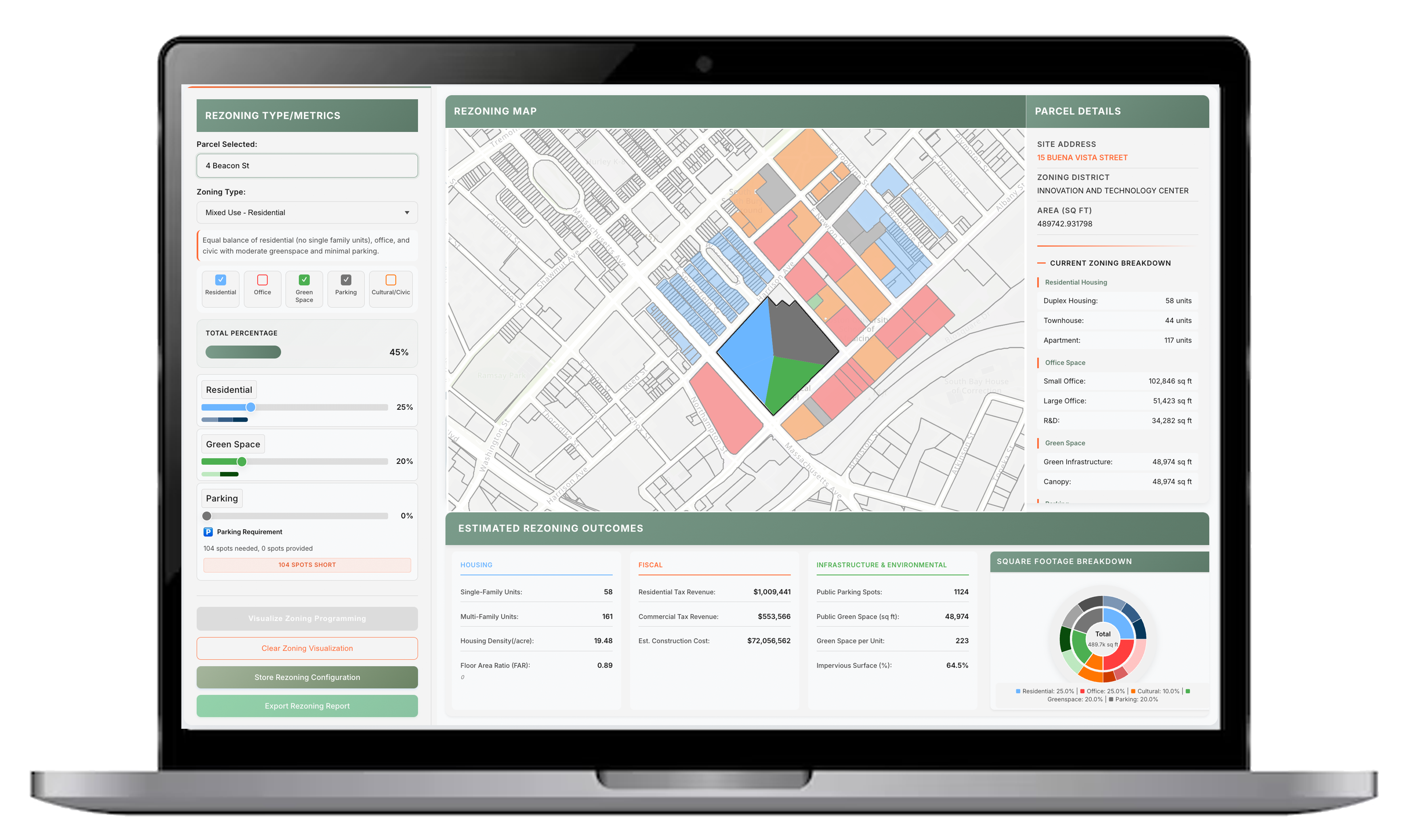
“With TangiblEmpact, we were able to adjust assumptions — say, increasing FAR, or shifting 10% of floor area from office to residential — and immediately see the effect on tax revenue, unit count, green space, parking allocation, and construction cost across all scenarios simultaneously.”
Neil Angus, FAICP
Director, Devens Enterprise Commission
What Changed
Before using TangiblEmpact, the planning team's typical process for scenario planning involved preparing separate analyses for each development scenario, spreadsheets for fiscal projections, written reports for zoning analyses, and static slide decks for presentation. Producing a revised scenario meant days of back-and-forth across documents.
Faster Scenario Development
Scenario iterations that previously would have taken days to prepare were generated and compared in real time, compressing the time of analytical work.
Centralized Evaluation
Examined scenarios, constraints, and outcomes in one place — providing the team greater efficiency and spatial visualization in their analysis.
Multi-Stakeholder Perspective
A single resource that displayed how each scenario performed across varying stakeholder priorities.
Customized Scenarios + 3D Modeling
The tool’s customizable backend allows teams to tailor scenario inputs to reflect local conditions, zoning regulations, and community priorities. The addition of 3D modeling enhanced the ability to evaluate building massing and spatial relationships.